
BLM Module 2: The Public Land Survey System Study Guide
1 of 34
Interpret and Write Descriptions of Land: The Public Land Survey System
---------------------------------------------------------------------------------------------------------------------------------
This module provides the foundational concepts and terminology of the Rectangular Survey
System: interpreting land location on a map, writing a description of the land using the
nomenclature of the Public Land Survey System, and emphasizing the importance of punctuation
placement.

BLM Module 2: The Public Land Survey System Study Guide
2 of 34
The objectives of this module are to help you: explain key land description terminology, apply
principles of Rectangular Survey System, interpret subdivisions of sections (aliquot parts), explain
excess or deficiency due to convergence, explain why lots were created, describe the preferred
writing method elements and proper use, and list the four most commonly used map types and
define their use for land descriptions.
---------------------------------------------------------------------------------------------------------------------------------
Lesson 1: Rectangular Survey System

BLM Module 2: The Public Land Survey System Study Guide
3 of 34
After completing this lesson, you should be able to: explain key land description terminology,
apply principles of Rectangular Survey System, interpret subdivisions of sections, and describe
the preferred writing method elements and proper use.
---------------------------------------------------------------------------------------------------------------------------------
The Rectangular Survey System was created to provide simplicity to interpreting and describing
any piece of land, located on a map or on the ground, and where practicable, its units are in a
rectangular grid form. Rectangular Survey information can be found in Chapter II of the
Specifications.
BLM Module 2: The Public Land Survey System Study Guide
4 of 34
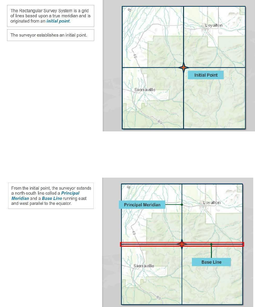
The Rectangular Survey System is basically a grid of lines based upon a true meridian and is
originated from an initial point. To begin the grid, the surveyor establishes an initial point from
which to begin surveying.
---------------------------------------------------------------------------------------------------------------------------------
From the initial point, the surveyor extends a north-south line called a Principal Meridian and a
Base Line running east and west parallel to the equator.

BLM Module 2: The Public Land Survey System Study Guide
5 of 34
Along the north-south line, the surveyor establishes township lines north and south from the initial
point. Each line is created at 6 nominal mile intervals. Along the east-west line, the surveyor
establishes range lines east and west from the initial point also at 6 nominal mile intervals. Each
of these 6 by 6 nominal mile squares is called a township.
---------------------------------------------------------------------------------------------------------------------------------
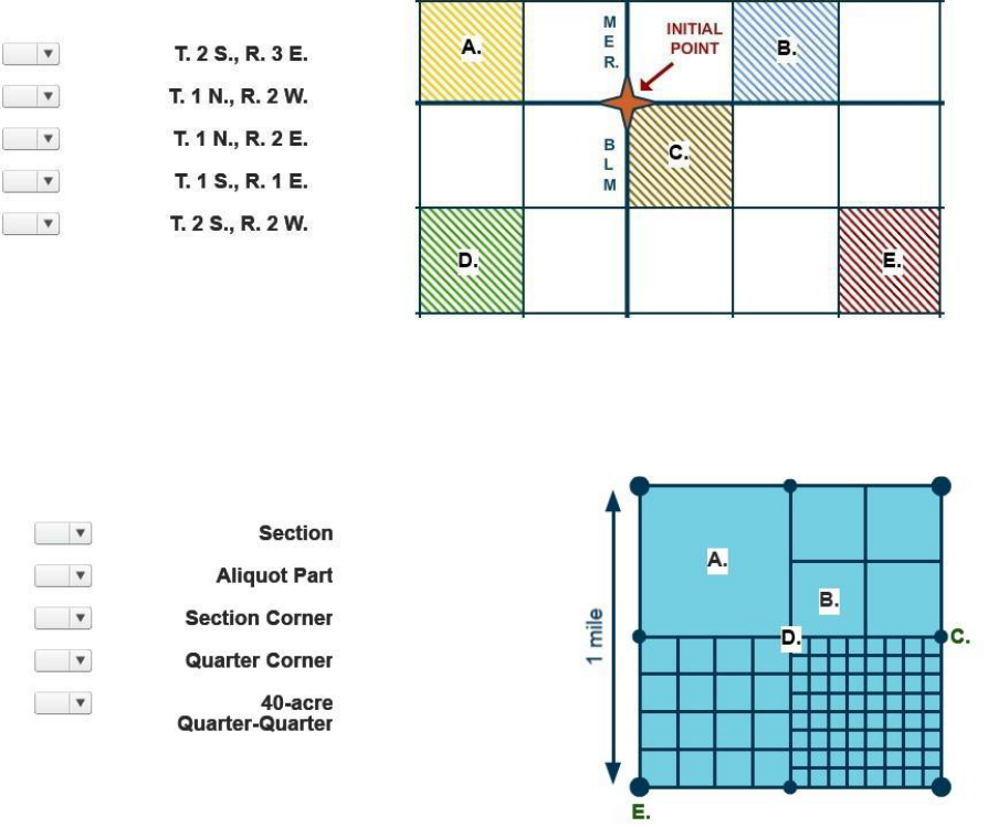
Correct Answers: A. Township Line, B. Principal Meridian, C. Range Line, D. Initial Point,
E. Base Line, and F. Township.

BLM Module 2: The Public Land Survey System Study Guide
6 of 34
Correct Answer: B. 5
---------------------------------------------------------------------------------------------------------------------------------
Each township is further subdivided into thirty-six sections of one square nominal mile each.
Section numbering begins at number one in the upper right northeast. Sections are numbered
right to left and left to right down the rows until reaching the lower right southeast section. This
wandering arrangement is based on how farmers plowed their land or “as the ox plows.” The
benefits of this numbering system guarantee that a section is always adjoined by its preceding
and succeeding section. A section will never end up next to a confusingly numbered section in an
adjoining township.

BLM Module 2: The Public Land Survey System Study Guide
7 of 34
When describing portions of regular sections, aliquot parts, or exact divisions of the whole are
used. In other words, quarters are described in their relative position within the section. Any
parcel listed as northeast, northwest, southwest, or southeast is a quarter part. A combination of
aliquot parts, for example two equal quarters, can be described as half of a section. Aparcel
reading north, south, east, or west is a half part. Later you will learn the use of “half of a half”
descriptions that must be avoided in writing descriptions of land.
---------------------------------------------------------------------------------------------------------------------------------
Along the township and range lines, corner monuments are set every nominal mile at all section
corners. Monuments, called quarter corners, are set at mid-point between each mile marker.
These monuments are called quarter corners because when connected, they form the legal
boundaries that divide each section into quarters. Quarter parts can be further subdivided into
quarters and each quarter equal to 40 acres. The 40 acre quarter-quarter is considered by BLM
as the standard land unit for management purposes. However, these quarters can then be
further subdivided into quarters and each quarter equals to 10 acres. These 10 acre quarters can
then be further subdivided into quarters and each of these quarters is equal to 2 ½ acres.

BLM Module 2: The Public Land Survey System Study Guide
8 of 34
Lesson 2: Excess or Deficiency by Convergence
---------------------------------------------------------------------------------------------------------------------------------
After completing this lesson, you should be able to: Explain the principle of creating lots within the
rectangular survey system due to excess or deficiency in land areas with a township or section.

BLM Module 2: The Public Land Survey System Study Guide
9 of 34
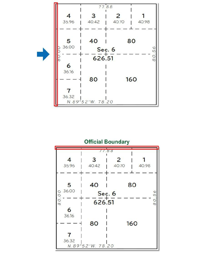
For various reasons, not all sections contain 640 acres, which is contrary to the plan of the
rectangular system as shown here. The sections along the north tier and the west range of a
regular township are often irregular sections and contain lots. These non-aliquot parts are
designated by section and given a lot number. Though lots may contain more or less than 40
acres, they are considered a subdivision unit of a section.
---------------------------------------------------------------------------------------------------------------------------------
As a surveyor works north from the initial point, range lines do not continue in a straight line
because of the curvature of the Earth’s surface. If not corrected, the township on the baseline
would contain more area than one further north.

BLM Module 2: The Public Land Survey System Study Guide
10 of 34
To correct for this convergence, surveyors establish guide meridians and standard parallels every
24 miles in each direction from the initial point.
---------------------------------------------------------------------------------------------------------------------------------
To compensate for loss in acreage to the convergence a land unit called lots was created. Lotting
usually occurs in the north and west of each township. This is due to excess and deficiency
in area created by convergence or because the township is abutting a previously surveyed
township. Lotting also occurs when special surveys such as mineral surveys, and the
meandering of rivers and lakes because the reduced land area around them cannot be described
in aliquot parts. Lots are numbered similar to the 36 sections of a township. Lots are normally
numbered starting in the northeast corner of the section in a counterclockwise direction but
because of irregularities of land features lot numbering systems do vary. Following are visual
examples of how a lotting scheme is portrayed on plats. Additional details can be found in
Chapter 3, Subdivision of Sections in the 2009 Manual of Survey Instructions.

BLM Module 2: The Public Land Survey System Study Guide
11 of 34
Displayed here is an example of typical lotting. Notice all quarters are aliquot parts. The lots
displayed here are equal. Also, notice how the lots are numbered. In the northeast quarter, the
lots are numbered right to left across the top. In the southwest quarter, the lots are numbered top
to bottom. In the northwest quarter, the lots are numbered right to left across the top and then
from the top down.
---------------------------------------------------------------------------------------------------------------------------------
Again, you must consider the Earth curves moving north. To adjust for this, the boundary lines
along the north and west sides of a township do not make a perfect square. Notice here each lot
includes a differing acreage. Starting at lot seven and moving up to lot four, you will notice the
acreage decreases as does lot one to lot four.
BLM Module 2: The Public Land Survey System Study Guide
12 of 34
The reality is the lines running north and south are slowly moving to the right due to convergence.
---------------------------------------------------------------------------------------------------------------------------------
The lines runningeast-west may be running into a previously surveyed area and therefore cannot
move past the official boundary.

BLM Module 2: The Public Land Survey System Study Guide
13 of 34
When navigable bodies of water are involved, such as a meandered river or lake, lots are used to
define those areas. The beds of those waters are not open to sale or homesteading and cannot
be made into aliquot parts within the section. It is important to note lot numbering procedures vary
from state to state.
---------------------------------------------------------------------------------------------------------------------------------
In these examples, the borders have been exaggerated so that you can see the defects in border
alignment. These are cases where the township runs into a previously surveyed area or have
been resurveyed under the rules set forth in the 2009 Manual of Survey Instructions. In the first
example, the east border is defective, in the second the south, and in the third both the east and
south borders.

BLM Module 2: The Public Land Survey System Study Guide
14 of 34
With few exceptions, lots are identified and described by the unique number it is assigned within
the section. You will learn how to reference lots in writing land descriptions in the next lesson,
Preferred Order and Preferred Writing Method.
---------------------------------------------------------------------------------------------------------------------------------
Correct Answer: B. False.
BLM Module 2: The Public Land Survey System Study Guide
15 of 34
When reading from a map or plat, you will notice various units of measures: units of linear
measure and units of area measure. These will most likely be represented by the terminology
used at the time the plat was created. During the early growth of our nation, the United States
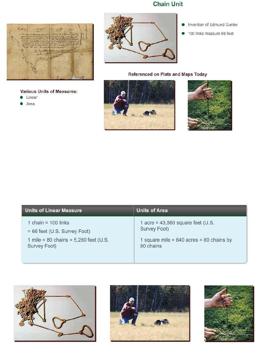
adopted the use of a linear measurement called the chain unit. It was the 17th-century invention
of Edmund Gunter, an English astronomer. Gunter’s link chain was 66 feet long and divided into
100 equal links. The chain unit term and measurement is still referenced on plats and maps today.
---------------------------------------------------------------------------------------------------------------------------------
As you see here in the chart, the chain measurement is used both in linear and area measures.
Regarding linear measure, a chain includes 100 links with each link being 7.92 inches. The 100
links measure 66 feet with 1 mile being equivalent to 80 chains when strung end to end.
Regarding area measure, one acre is equivalent to 43,560 square feet formed into a square. One
square mile equates to 640 acres or 80 chains by 80 chains.

BLM Module 2: The Public Land Survey System Study Guide
16 of 34
Another historic unit of measure was the pole or rod or perch. Like the acre, common units of
linear measure were brought to the American Colonies from Europe. A pole or rod of an exact
length can be used as the “standard” like other identical forms measuring tools can be copied.
The word perch is derived from the Latin word meaning a pole or staff.
---------------------------------------------------------------------------------------------------------------------------------
The quantity of land within the bounds of a description is most commonly expressed in “acres.” It
is said that during the Middle Ages, an acre was the amount of land that could be ploughed in one
day with a yoke of oxen. One acre equals 43,560 square feet, and is approximately the land
contained in a 209 foot by 209 foot square.

BLM Module 2: The Public Land Survey System Study Guide
17 of 34
When preparing land descriptions in accordance to the “Specifications,” the terms “land” and
“area” are used when referring to a group of parcels that have common boundaries. The terms
“lands” and “areas” are used when referring to a group of parcels being described that do not
have common boundaries.
---------------------------------------------------------------------------------------------------------------------------------
If the lands described are entirely surveyed, the legal acreage as shown upon the official plats of
survey is used. Where unsurveyed land is included, the acreage as shown upon the official
protraction diagrams of the township will be used. Where land is not returned on an official survey
plat and there is no official protraction diagram, an approximate area will be given in even acres.

BLM Module 2: The Public Land Survey System Study Guide
18 of 34
Protraction diagrams serve as a plan of survey for if an Official Cadastral Survey were to be
performed over unsurveyed land. See Area in Chapter II of the Specifications for more
information.
---------------------------------------------------------------------------------------------------------------------------------
Correct Answer: A. 66 feet

BLM Module 2: The Public Land Survey System Study Guide
19 of 34
Correct Answer: 40 acres
---------------------------------------------------------------------------------------------------------------------------------
Correct Answer: D. 1,555 feet x 1,320 feet

BLM Module 2: The Public Land Survey System Study Guide
20 of 34
Lesson 3: Preferred Order and Preferred Writing Method
---------------------------------------------------------------------------------------------------------------------------------
After completing this lesson, you should be able to: explain the preferred order and preferred
writing method for a description of land and describe the importance of proper punctuation and
how improper punctuation can adversely affect written descriptions.

BLM Module 2: The Public Land Survey System Study Guide
21 of 34
The preferred numerical order of listing of a land description is to begin with the lowest range
number. Also start with the lowest number within each range by the township numbers.
---------------------------------------------------------------------------------------------------------------------------------
Where townships east and west of the principal meridian or north and south of the base line or
both are involved, first list those north and east of the initial point, followed by those north and
west, south and west, and finally south and east. Describe all the parts of each township and
range before proceeding to the next township and range.

BLM Module 2: The Public Land Survey System Study Guide
22 of 34
For sections, begin with the lowest-numbered section in each township.
---------------------------------------------------------------------------------------------------------------------------------
First, give the lot numbers in order.

BLM Module 2: The Public Land Survey System Study Guide
23 of 34
Then list the subdivisions within each quarter section in the order NE, NW, SW, and SE. If parts
of the quarter-sections are to be described, follow the same order and describe all the parts of
each quarter section before proceeding to the next quarter-section.
---------------------------------------------------------------------------------------------------------------------------------
Tracts should follow the sections because a tract is part of a township, as is a section. It is
numbered the same as a section, beginning with 37 or the next highest unused numerical
designation to avoid confusion with section numbers. Tracts should be listed before
nonrectangular surveys, such as mineral surveys or donation land claims.

BLM Module 2: The Public Land Survey System Study Guide
24 of 34
Before you can write a description of land, you must first understand what the references mean. A
proper aliquot part description should contain all of the reference elements within it: principal
meridian, the state the land is in, township and range, section, and lots or aliquot parts. In this
lesson, you will learn some of the basic abbreviations and the order in which a description of land
is written. In this example, we begin with the fictitious Bureau of Land Management Principal
Meridian or BLM Meridian, (the State the land is in). Next, comes the township and range. Thisis
written as T. 2 N., R. 3 E.. and pronounced township two north, range three east. Next is the
section and any subdivision. Continuing with our example, this is written as sec. 9, SE1/4 and
pronounced as section nine, the southeast quarter. Finally, the area in acres is described. This
happens to be a quarter of one section and therefore is equivalent to 160 acres. See Preferred
Writing Method in Chapter II of the Specifications for more information.
---------------------------------------------------------------------------------------------------------------------------------
Please take a few moments now and review the abbreviations with their references.

BLM Module 2: The Public Land Survey System Study Guide
25 of 34
The usual punctuation is omitted in the aliquot part description. The period is omitted after N, NE,
S, SE, etc., within the aliquot parts description, and there is no comma and no space between
symbols indicating a quarter-quarter section (NE1/4SE1/4).
---------------------------------------------------------------------------------------------------------------------------------
The use of a comma is significant in writing the descriptions of the subdivisions of a section. A
comma means AND THE and the absence of a comma means OF THE. The improper use or
placement of a comma could drastically change an aliquot description and the intended acreage
to be described. For example, given the description NE1/4SW1/4SE1/4 without a comma
describes an aliquot part of 10 acres. With a comma, as such NE1/4, SW1/4, SE1/4 describes
three aliquot parts totaling 480 acres.

BLM Module 2: The Public Land Survey System Study Guide
26 of 34
The proper use of the comma in an aliquot description is as follows: The NW1/4,
NE1/4SE1/4SW1/4, NW1/4SE1/4, describes three aliquot parts containing 210 acres.
---------------------------------------------------------------------------------------------------------------------------------
Correct Answer: B. Lowest range number.

BLM Module 2: The Public Land Survey System Study Guide
27 of 34
Correct Answer: B. False
---------------------------------------------------------------------------------------------------------------------------------
Correct Answer: B. NE1/4SW1/4SE1/4
BLM Module 2: The Public Land Survey System Study Guide
28 of 34
Lesson 4: Survey Plats, Maps, and Diagrams
---------------------------------------------------------------------------------------------------------------------------------
After completing this lesson, you should be able to: list the four most commonly used map types and
define their use for land descriptions.

BLM Module 2: The Public Land Survey System Study Guide
29 of 34
In this lesson, you will be introduced to the four most common map types you will use when
interpreting and writing descriptions of land. These are: the Surface Management Areas Map,
Official Plat of Survey, the Master Title Plat or MTP, and Protraction Diagram. Please note that
there is a legal distinction between the terms of map and plat. Official surveys are always referred
to as a plat. Let’s begin with an overview of the Surface Management Areas map.
---------------------------------------------------------------------------------------------------------------------------------
The small scale map, BLM Surface Management Map, can be used to find the general area of a
parcel of land and its relation to major landmarks and transportation routes. Small scale maps
also are a handy way to find a location using the PLSS grid. But it is important to know that small
scale maps DO NOT necessarily show the correct and current land ownership and boundary
information! Displayed here is an example of a Surface Management Map.

BLM Module 2: The Public Land Survey System Study Guide
30 of 34
The Official Plat of Survey is commonly called a survey plat or plat. This is the record of official
government survey and includes the survey measurements and calculated acreage. It also
displays land parcels that do not conform to the rectangular survey system. These plats can be
found at BLM State Office Public rooms, online at some BLM State Office web sites or General
Land Office (GLO) Records Automation web site (The Official Federal Land Records Site). An
example of a survey plat is shown here.
---------------------------------------------------------------------------------------------------------------------------------
The Master Title Plat or MTP shows Federal land ownership information, including rights and
reservations the Government retained on lands convey (patented) to private individuals. These plats
can be found at BLM State Office Public rooms, online at some BLM State Office web sites
or General Land Office (GLO) Records Automation web site (The Official Federal Land Records
Site). An example of an MTP is shown here.

BLM Module 2: The Public Land Survey System Study Guide
31 of 34
A Protraction Diagram is prepared for the purpose of describing unsurveyed land areas. In
essence, the protraction diagram can be considered a “plan of survey” for if and when an on-the-
ground survey was performed (i.e. it governs until an official survey is performed). The diagram is
approved for the Director by the Chief, Division of Cadastral Survey, and filed in the respective
state offices of the BLM. An example of a Protraction Diagram is shown here.
---------------------------------------------------------------------------------------------------------------------------------
Correct Answers: A. Surface Management Map, B. Official Plat of Survey, C. Master Plat Title,
and D. Protraction Diagram.

BLM Module 2: The Public Land Survey System Study Guide
32 of 34
Having completed this module, you should now be able to: explain key land description,
terminology, apply principles of Rectangular Survey System, interpret subdivisions of sections
(aliquot parts), explain excess or deficiency due to convergence, explain why lots were created,
describe the preferred writing method elements and proper use, and list the four most commonly
used map types and define their use for land descriptions.
BLM Module 2: The Public Land Survey System Study Guide
33 of 34
Quiz Answer Key
1. Review the graphic. Match the letter to its corresponding part on the image.
Correct Answers: A. T. 1 N., R. 2 W.; B. T. 1 N., R. 2 E.; C. T. 1 S., R. 1 E.; D. T. 2 S., R. 2. W.;
and E. T. 2 S., R. 3 E.
2. Match the letter to its term.
Correct Answers: A. Aliquot Part, B. 40- acre Quarter-Quarter, C. Quarter Corner, D. Section, and
E. Section Corner.
3. How many nominal miles wide and high is a Township versus a Section?
A. Township: 1 mile and Section: 6 miles
B. Township: 10 miles and Section: 4 miles
C. Township: 5 miles and Section: 1 mile
D. Township: 10 miles and Section: 5 miles
E. Township: 6 miles and Section: 1 mile
Correct answer: E. Township: 6 miles and Section: 1 mile
4. True or False: For management purposes, BLM considers 160 acres to be the standard land
unit.
Correct Answer: False

BLM Module 2: The Public Land Survey System Study Guide
34 of 35
5. 132 feet is equivalent to how many chain units and how many feet is the equivalent of 5
chains?
A. 2 chain units and 330 feet
B. 4 chain units and 165 feet
C. 3.3 chain units and 200 feet
Correct Answer: A. 2 chain units and 330 feet
6. Which written description of land is represented in the graphic?
Correct Answer: C. BLM Meridian, Idaho T. 1 N., R. 2 E., sec. 12, NW1/4
7. Which is the correctly written description for aliquot parts displayed in the graphic?
Correct Answer: A. NW1/4, NE1/4SE1/4SW1/4, NW1/4SE1/4
8. What is used to find the initial reference area of the parcel of land in question?
A. Surface Management Map
B. Map of Official Survey
C. Master Title Plat
D. Protraction Diagram
Correct Answer: A. Surface Management Map
BLM Module 2: The Public Land Survey System Study Guide
35 of 35
9. What is used to review the survey measurements and calculated acreage and is
commonly referred to as a survey plat or plat?
A. Surface Management Map
B. Official Survey
C. Master Title Plat
D. Protraction Diagram
Correct Answer: B. Official Survey
10. What is used to review Federal land ownership information?
A. Surface Management Map
B. Official Survey Plat
C. Master Title Plat
D. Protraction Diagram
Correct Answer: C. Master Title Plat
11. How many miles in each direction from the initial point do surveyors establish guide
meridians and standard parallels to correct for convergence?
A. 1 mile
B. 6 miles
C. 24 miles
D. 36 miles
Correct Answer: C. 24 miles
12. True or False: When bodies of water are involved, such as a meandered river or lake,
lots are used to define those areas that cannot be made into aliquot parts.
Correct Answer: True
